

Whether you are just learning to bike, a tourist that want to join all those people you see riding from Fisherman’s Warf or want to experience San Francisco in a new way, the ride to Fort Point and back is a beautiful ride along the San Francisco Bay to the Golden Gate Bridge.
Distance = 11.36 miles
Difficulty = Cake! Full of easy alternatives to on-road riding for the novice or “rusty” rider.
Download the Route Sheet here: Directions – Inagural Run
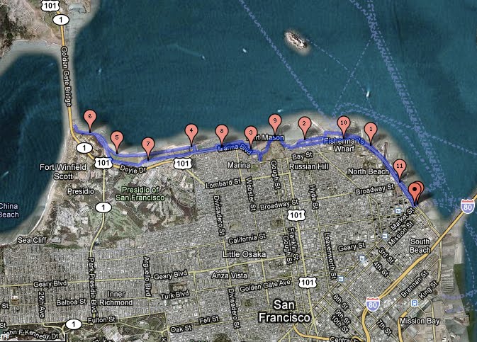
You can find a detailed map of The Inaugural Run HERE.
OUR INAUGURAL RUN TO THE GOLDEN GATE

Beginning at the Ferry Building means traveling along the Embarcadero, where there is both a narrow bike lane on the street and a wide sidewalk. Drivers along the Embarcadero can be aggressive and unforgiving while pedestrians are absent minded and slow. Both ways are more congested on the weekend but it’s not unusual to alternate between the two to avoid vans or a particularly slow group of Sunday walkers.
The first fork in the road comes at the junction of Kearny and North Point where the Embarcadero ends and the straight through is the bumpy brick path of the trolly tracks. If you feel safest on the sidewalk and have zen-like frustration tolerance for slow, absent minded tourists . . the best solution is to enter the pavement towards Pier 39 and enjoy this Scenic Route through the marina, Pier 39 and Fisherman’s Wharf. There will be lots of opportunities to take photos, but TONS of slow pedestrians that have the right of way.

Since we original wrote this article, a bike lane and bike turn signal has been installed at the intersection of Embarcadero and North Point Street that makes taking the route along North Point Street much easier to take. (See Run Over Route, below.)

Intersection of Embarcadero and North Point, courtesy of Google Maps
Scenic Route
Expect this area to be extremely tiresome because pedestrians and cyclists coexist about as well as toddlers and teenagers. It’s all about me and nobody’s happy. Take a deep breath because it’s only a short span that will make you reevaluate your own habits of jay walking and walking while talking on the cell. Just follow the road through Fisherman’s Wharf through Aquatic Park where it meets Van Ness Avenue which is where this route meets back up with the Run Over Route.


Miko at the Entrance to the Aquatic Park Trail
ALTERNATE: The Run Over Route
With the addition of the bike turn signal at the intersection and bike lane along North Point Street, and the thought of commingling with throngs of pedestrians makes your skin crawl, you’d best admire Fisherman’s Wharf from a distance and instead turn left at the bike signal and head up North Point Street. This is called the Run Over Route (click here) for a reason: buses, vans, taxis, even big rigs are out to run you over – for the sheer joy of crushing cyclists!
(UPDATE: Thanks to the San Francisco Bike Coalition, part of North Point is now a dedicated Bike Lane in July 2010)

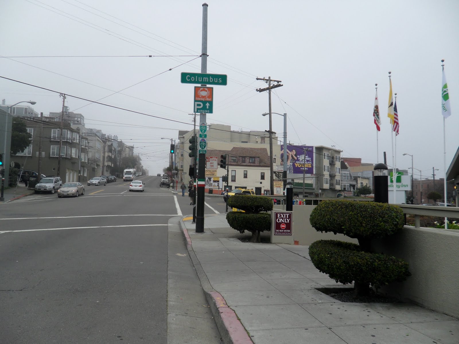

Patience my friends between stop lights and aggressive drivers, make a right at Columbus (right before the uphill) then head left on Beach. You will pass over most of the detour and come out at the top before heading down towards the hill at Fort Mason (a.k.a. the Celebrity Fit Club).

Looking up Celebrity Fit Club
After passing through the short bike path at the end of Beach Street, near the Maritime Museum, keep mind of your surroundings. It’s not because we think you’re stupid but because when you hit the downward slope at this part you want to get some speed (barring annoying, loitering tourists and cars parking) before heading up the hill (or as I like to call it the Celebrity Fit Club) towards Fort Mason.
The Celebrity Fit Club hill is the only challenging part of this ride. Some heavier bikes (and loftier fitness levels . . . ahem) may not be UP for it. Getting into a good gear setting and finding the right pace can make all the difference. In the meantime you can “like totally pause” or alternately walk your bike.

Jon taking a pause at the top of Celebrity Fit Club.
For what it’s worth, it’s genuinely joyful to reach the top and enjoy the views of Fort Mason, the Marina district, Crissy Field and the Golden Gate from this vantage point beneath the trees (and perhaps a perfect time for a water break and picture op me thinks).


The path gets more intuitive here with slews of other bikers around to follow. Coming out of the park here we suggest biking through the parking lot at Fort Mason, which runs along the waterfront – for all the reasons we like parking lots and because it’s more scenic.

After rejoining the bike path on Marina Boulevard, at the beginning of Crissy Field there’s the option to continue on the paved bike path or brave it along the dirt path along the waterfront. The views along the water are magnificent and we recommend taking this path at least once towards the bridge.

Crissy Field Bike Path
Alternately the bike path along Crissy Field is clearly marked and sufficiently wide for both joggers and bikers, for a swifter pass through the area. We recommend taking this route back.
 Where you decide to end your ride and turn back is up to you. Miko wanted as close to the Golden Gate Bridge’s underbelly as possible, while Jon wanted confirmation that Fort Point is actually one of the key buildings in Grand Theft Auto San Andreas (and now Watchdogs 2).
There are rest spots with bathrooms at the end of the road to take the weight off your saddle sore bottom, along with plenty of great places to pose for your Christmas card photo.

Jon and Miko take a quick “pause” at the sea wall near the Warming Hut
Riding back is just backtracking with two small pieces of advice: (1.) the hill through the park at Fort Mason is less steep if you take the path on the right that winds it’s way back to the hill (which is “WEEE!” fast fun on the way down compared to “HELP!” dying up).
And (2.) when returning on the Embarcadero make a choice between pavement or street based on your first encounter. On the street pay more attention to lights and traffic in this direction as there is a lot more stopping and starting and the bad drivers that will make a right hand turn from the left hand lane, as seen in the video below:
This first ride is a satisfying run for those learning to get their bearings on a bike and to see and photograph the city’s many tourist destinations in a short amount of time. The route to the bridge will be the springboard to many of our other routes including the delectable ones into Marin . . . good thing is it never gets old.

Great stuff. This has been one of my favorite rides for years, although I usually start at my place near 7th & Harrison, then run out to Mission Bay and past AT&T Park back up to the Ferry Building where your ride starts. My version is about 20 miles round trip for me.
Everyone loves what you guys are usually up too. This type of clever work and exposure! Keep up the good works guys I’ve added you guys to my blogroll.
Does your site have a contact page? I’m having trouble
locating it but, I’d like to shoot you an e-mail.
I’ve got some suggestions for your blog you might be interested
in hearing. Either way, great site and I look forward to seeing it grow
over time.
Hi Mitchell,
We’ve updated our About Us page to include our email. We’ve also sent you an email.
Thanks!