Find Real Trips and Real Tips from the Couple that Just Likes to Bike.
Home Page
Welcome to WeLikeToBike.com, where you’ll find Real Trips and Real Tips from the Couple that Likes to Bike!
San Francisco’s natural beauty and accessibility by bike started our passion for cycling. From our first ride across the Golden Gate Bridge, we were hooked! Through the years we have chronicled our cycling journey from classic San Francisco bike routes, to maintenance tips, to funny stories. But after years of cycling the Bay Area’s roads and trials, our path veered from the West Coast to the East Coast, but cycling remains a constant.
While we may have relocated, our passion for cycling influenced the selection of our new home by making us look at the local biking culture, accessibility, and trails. After considering several different locations, we selected St. Petersburg, Florida as our new home. The Tampa Bay Area has several paved bike paths which will eventually circumnavigate Pinellas County, and the roads with bike lanes are expanding and allow you to connect a ride from the Sunshine Skyway Bridge to Clearwater Beach and beyond.
WeLikeToBike now has trips, stories, and tips from Bay to Bay & Beyond!
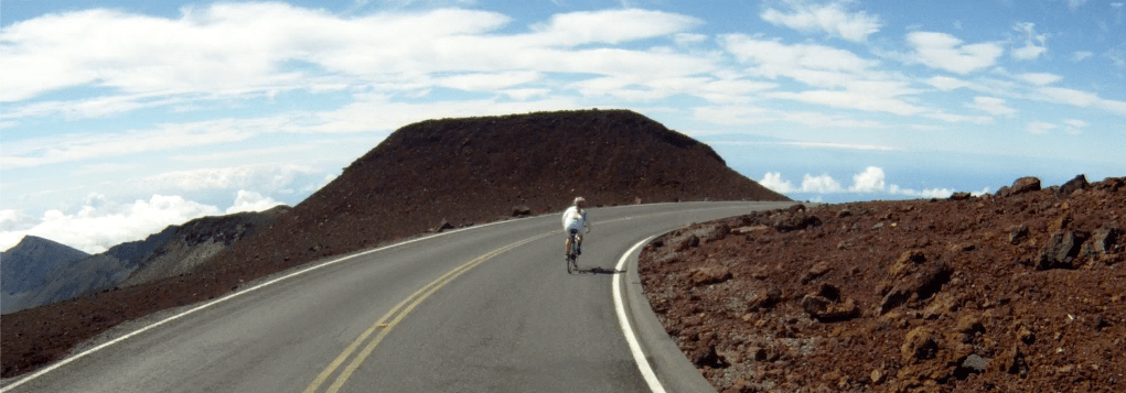
Your view of the world from the top of Haleakala, Maui, Hawaii
Hawaii is known for its visitors, vegetation, and vistas. One of the best views is from the top of Maui’s tallest volcano, Haleakala. From here you can see the ocean, the caldera, and other Hawaiian islands. At an elevation of 10,000 feet above sea level, the peak of the mountain it even gets snow in the winter. Tourists flock here every morning to see the sunrise at the top of the top of the “House of the Sun”. We had heard rumors of this descent before we came to Maui, so we decided to check it out for ourselves. What we found was an incredible descent, the likes and length of which could be found nowhere else in the world. So what’s a biking couple to do when there’s 38 miles of paved switchbacks? We rented road bikes and hopped a ride to the top! What we found can only truly be appreciated in person, but by video is the next best thing! Enjoy!
The Route & Stats
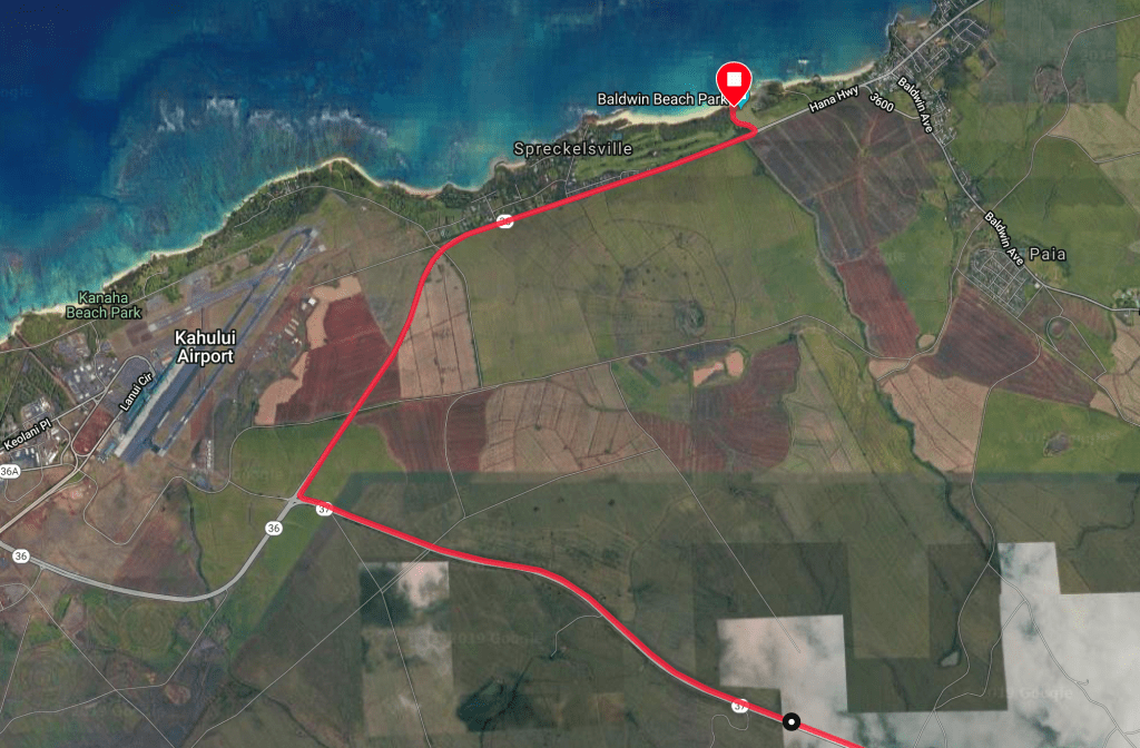
Overview of the route from the summit to Baldwin Beach
Distance from Summit to Baldwin Beach (near Paia): 38.70 miles
Elevation Loss: 10,000 feet (3,048 m)
Difficulty: Not for the feint of heart. Being a good descender and knowing your limits are essential to this ride. While there are commercial tours (with motocross helmets and comfort bikes) offered starting from the lower slopes (~26 miles of descending), the technical nature, high winds, and vast number of tourists at the upper section lends itself to a myriad of potential dangers. Plan ahead, check the weather, and be careful as you never know what this mountain will throw at you.
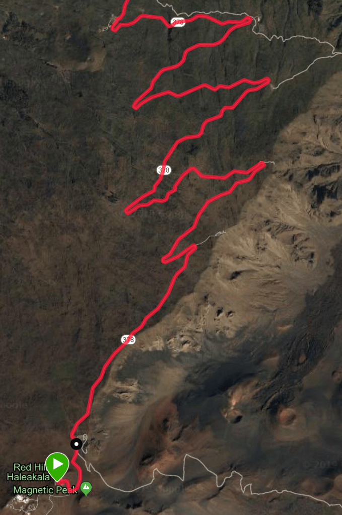
Haleakala National Park – The Upper Slopes
Most of the volcano and the upper portion of the descent is part of Halealaka National Park. The park is home to an observatory and offers self-guided hiking tours. Commercial bike tours have not been allowed to start from the summit since the late 2000’s, so you will need a second rental car, or a friend to drop you off at the top if you don’t want to cycle up the mountain. If you are interested in climbing to the top, check out the Cycle to the Sun race.
The cycling route here is very simple, follow the road! This first portion of the ride takes you along technical switchbacks for 10 miles to the National Park’s visitor’s center and is the focus of Part 1 of the Descent of Haleakala.
The first 10 miles from the summit parking lot to the Visitor’s Center
The upper slopes of Haleakala mountain in Hawaii provide some of the most breathtaking vistas on Maui. This part of the 38-mile descent to Baldwin Beach, near Paia takes you through the upper switchbacks to the National Park’s visitor’s center where Part 2 will pick up.
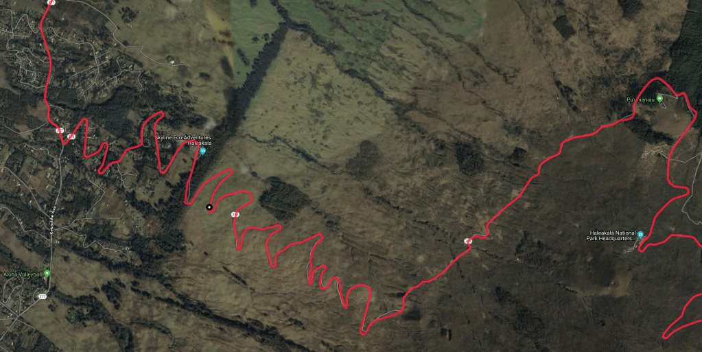
The Lower Slopes
The lower slopes of Maui’s Haleakala volcano take you through the cloud forest, above the cane fields, and finally end with a trip to the beach. This part of the 38-mile descent to Baldwin Beach, while less technical, is no less stunning than the upper portion of the ride.
Once you exit the national park, continue to follow the road until it dead ends into Route 377, Kekaulike Avenue, where you make a right (we froze the video on the sign).
Continue following Route 377 until it also dead ends at Route 37, the Haleakala Highway, where you once again make a right.
Finally, follow the Haleakala Highway the next several miles as you pass the cane fields all the way to the outskirts of Kahului, near the airport. At Route 36, make a right (again) and follow the road all the way to Baldwin Beach, a convenient place to park your second car or meet your ride to the top.
Once you arrive at Baldwin Beach, your ride is complete and its time to relax and find some lunch in Paia, which is just a short walk or ride just up the road.